Showing posts with label TW on the road. Show all posts

Tuesday, July 24, 2018

Sunrise to Sunset at the Grand Canyon

I landed in Arizona  late in the afternoon, but as soon as I'd checked into my motel room and purchased a few supplies at the local WalMart, I headed for the Canyon. It didn't matter to me that it would be getting dark.  In retrospect, I'm entirely glad I went when  I did -- not that driving through unknown country in the dark was fun, but my first view of the Grand Canyon was a twilight view. There's something about the dawn and dusk -- their fleetingness -- that makes them especially beautiful.

I visited the Canyon three more times that week,  at one time watching the sunrise with a few dozen similarly crazy souls, and have arranged some shots to represent a day spent at the canyon. 

MORNING

Shortly after six a.m, on a cold and windy April morning


On an old mining trail, a young couple stands transfixed by the scenery. 


MID-MORNING


From the observation room of the Desert View Tower, about 26 miles from the visitor's center


DAY


These and the other "DAY" shots are taken from a helicopter.


Of course I looked down. How could I not?


DUSK

These were taken the same day I arrived in Arizona.


This guy either had nerve or brown underwear, because the wind was blowing at ~30 MPH.


I spent that first evening at the Canyon walking along the rim, soaking in the view and shivering a little in the cold. I hadn't anticipated the wind, and so left my jacket in my car. The clouds rolling in --  there was rain along the north rim -- meant that I couldn't see the stars come out, so I decided to leave while I had enough light to find my car. 


I hope to visit the Canyon again one day, to hike into the interior and spend a night there -- but I'd want to have company! 


Sunday, July 22, 2018

Encompassing Flagstaff: Red Rock State Park

The red cliffs of Sedona, taken from the air on my flight into Flagstaff. I thought this was the Grand Canyon, and...so did most everyone else on the plane. I realized my mistake once I'd driven northwest to the Grand Canyon and realized a plane approaching Flagstaff from the south would be nowhere near the GC..


Working on that video yesterday made me realize...I'd never finished my Encompassing Flagstaff photo collection, so named because during the week of April 7 - April 14, I visited points north, south, east and west of Flagstaff, Arizona, using it as my base.     Previous posts covered a few national park tours, the town itself, and Mars Hill.   Now witness...Sedona! Well, mostly Red Rock State Park.  Sedona has a well-deserved reputation for being fantastically beautiful, as cliffs of red rock overlook the town itself. I got there early in the AM and decided to do some hiking at a state park outside of town, and when I finished I was so tired and the city so fantastically full of people I decided "Nope, going back to Flagstaff". 


Driving to Sedona. The road south from Flagstaff is extraordinarily pretty, but also extraordinarily inappropriate for multitasking, so I didn't take many more until I was out of the dangerously beautiful woods and cliffs.

South of Sedona, taken while driving either to or back from Jerome, a place I visited solely on the merits of it being, quote, "cute". I was there waaaaaaaaaaaaaay too early, but I am a man of principles, namely "Wake up at dawn and see it before the tourist mob shows up!"

Jerome, AZ. Succeeding streets are above you when you visit, and I found this distressing.


Hiking at Red Rock State Park. I went on several different trails out here,  first an easy one to get the lay of the land and then a hill ascent. I then did another hill ascent, because when I am on vacation I sometimes go overboard.  According to my phone, I logged 18K steps this day. 


Wide shot, continued


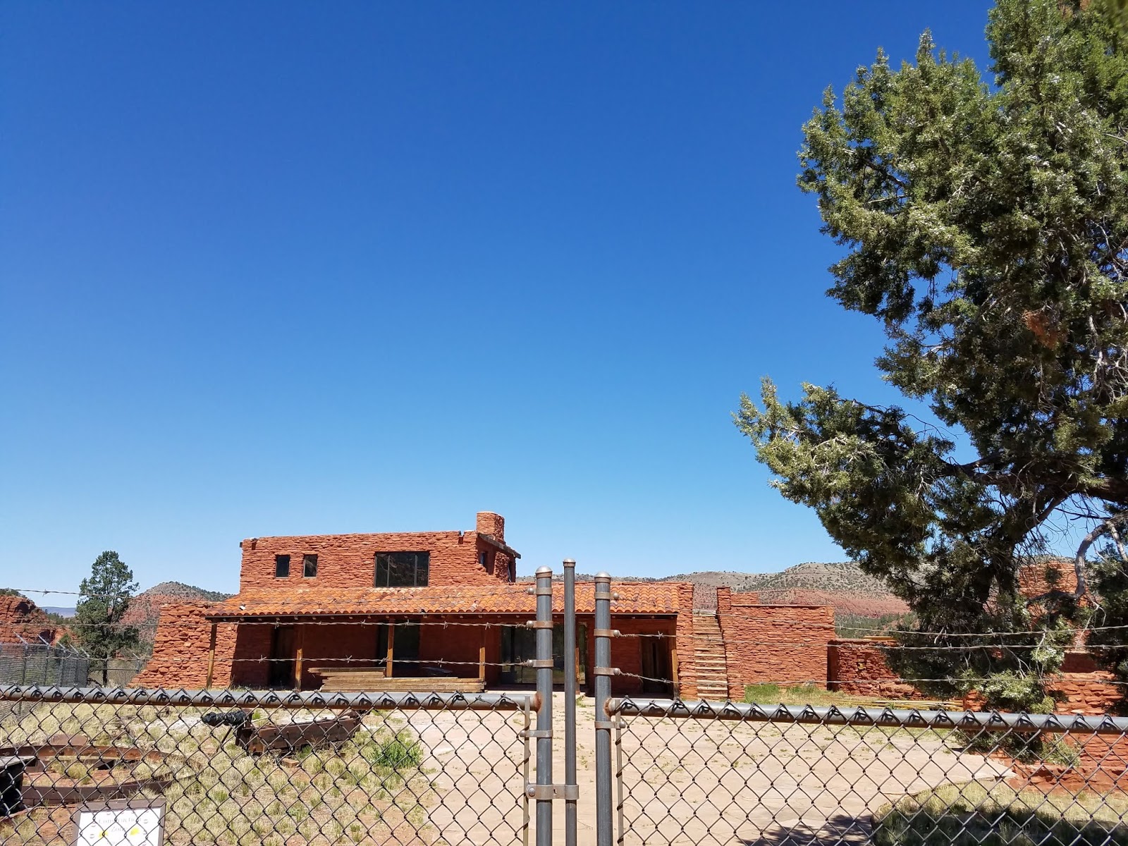
The House of Apache Fire, which sounds terribly dramatic. It even as a trail named after it.  If I remember the signs correctly, the house was built to imitate indigenous architecture, despite being itself relatively modern (1947).     This is probably the least photogenic way to approach it.  When verifying I was remembering then name correctly I found a page of different shots of the house, taken at a time when the park was much more verdant. 


Driving back to Sedona


I actually took this shot because of the Burger King.  To its credit, Sedona must have some kind of building code that forces structures to fit a certain aesthetic. 


Sedona from the air again, this time flying back home


Now that I've finally posted my helicopter GC video, I can share some photos. Look for those a little later in the week, possibly tomorrow.


Monday, February 12, 2018

Moundville

I have finally broken ground on this year's study series with Everyday Life of North American Indians (© 1979), but before I start posting reviews and such I'd like to share some photos from a day trip I took with some friends three years ago. Our destination was Moundville, Alabama, site of the Moundville Archaelogical Park.


The park is the site of an ancient and abandoned city associated with the Mississippian culture. Several sites like these exist in the eastern United States: the largest place is Cahokia, in western Illinois (very near St. Louis, Missouri).  I've heard of another mound near Mobile, but it is not accessible by road. "Moundville" was abandoned prior to the arrival of Europeans, much like the city-sites of the Anasazi.  At its height, it may have had a thousand people. As with the Anasazi, it is believed that the inhabitants of this place merged or became the tribes which later lived in the region -- in this case, tribes like the Chickasaw.   The park now contains 21 mounds, but early reports refer to 30.


After entering the park at the visitor's center in the left background of this photo, visitors will see them a wide field  dotted with grassy mounds, with a circular road connecting them. This photo is taken atop the largest mound, considered to be the chief's by virtue of its size.


There are about 77 steps -- I've never counted myself, but before I took this shot back in May 2015, a young boy and his father were descending, and the boy counted nosily. I'll give him the benefit of the doubt!


At the far end of the circle is an air-conditioned museum, which houses artifacts and the expected information about the park, and the possibly political or religious uses of the mounds. 


One of the exhibits.


Behind the museum are a few smaller mounds, plus ponds formed from the depressions left from excavating the dirt to build the original mounds.


Another area of the park houses three artificial huts built in the style of residences, and each contain half-melted plastic figures which once resembled humans doing the sort of things one expects museum exhibits to do -- burying people, marrying, that sort of thing.  In their melted state they're rather gruesome.  Enjoy another shot of the placid fields instead!


The Black Warrior River, which the city overlooked and which was its lifeblood, I'm sure. As I stood here I could almost imagine seeing hostile war-boats rounding the curve of the river.  Unlike the Alabama river, the Black Warrior River remains navigable to heavy industrial and commercial traffic. (The Alabama river is so constricted by dams and such that it's mostly used for pleasure craft and fishing these days.) 


Moundville is intriguing for its mysteries: why did people build it, remain a few hundred years, and then melt away into the forest? Cahokia had a similar fate.  There are just so many stories which have played out across familiar landscapes that have escaped the record completely. All we can do is stare, wonder, and probe the ground for answers.


Sunday, November 19, 2017

North Alabama III: Beautiful Buildings and Curious Stories


Another purpose of my weekend in northern Alabama was to visit cities I've heard of, but never visited -- Florence, Muscle Shoals, and Decatur.  Muscle Shoals earned a name for itself in the 1970s when it became a center for music production, commemorated in the Lynard Skynard song "Sweet Home Alabama".   My main goal, however, was to see a bank in Florence which is built as a replica of a unique antebellum home.


The original house was unusual in that its two-story colonnade completely encircled the building. Known as the Forks of Cypress, the house burned in the mid-20th century. The columns stand today and are almost visible from the road -- at least, in winter when there's no leaf cover --  but the grounds are only opened twice a year to the public.   Two buildings have been modeled on the Forks of Cypress: this bank and a private home.   The Regions Bank version strays a bit by having a rear addition that juts beyond the colonnade, but even so it's a beauty.

Downtown Florence in general is the picture of main street urbanism. 


I took numerous shots of downtown Florence's main street,  utterly taken by the buildings' close-knit variety. This is a city, not  strip malls and collector roads!


Near Seminary Street, the location of the bank, sits this public park -- right in front of the public library, which you can see to the left. 


(Still my favorite shot from the weekend...)


In downtown Sheffield, opposite the river, there is a statue that commemorates the musical scene of the 1970s. 


Downtown Sheffield, which I found only by getting lost trying to find Florence. 


Speaking of getting lost, I did it  soon after this while navigating down to Dismals Canyon. I failed to notice that my highway "continued" via left turn, and wound up going further south than expected. I entered a curious town called "Phil Campbell".  I stopped for gas and prompted the clerk, "I guess Phil Campbell must have been some kind of man to get the town named after him?"  She didn't know who he was, though. She didn't know how to get to Dismal Canyon, either. She said she was from Spruce Pine,  which despite her tone was not in another country, but ten miles up the road. I looked up ol' Phil when I got home, though, and discovered he was a carpenter who was asked to build a railroad depot and sidings  so that a local businessman could develop a town. Campbell was rewarded by having the new town named after him, Phil and all. Much of the town was destroyed in the 2011 Super Outbreak of tornado which so savaged northern Alabama, but a grand gathering of people named Phil Campbell raised money for its relief.


That story may have some bearing on this mural.

I would definitely return to Florence,  hopefully during a weekday when its main street was active, or perhaps during its spring Renaissance Faire. I have friends who dress up as knights and such and attend there, anyway!